EVERYTHING YOU WERE TAUGHT WAS A LIE. PART 8
TRUE LOCATION OF ANCIENT BABYLON
Among the lies we have inherited, is the location of Babylon among them?
To find out the truth, we will be using Scriptural, academical, geographical, geological as well as historical facts.
If you haven't read the previous series, please do so for a clearer understanding.
Also, because this is a truth blog, we use the RESTORED Name of our Father, YAHUAH and Son, YAHUSHA as recorded in the original Yahudym/Hebrew language.
YaramYAHU/ Jeremiah 51:29
"And the land shall tremble and sorrow: for every purpose of the ALUAH shall be performed AGAINST BABYLON, to make the land of Babylon a DESOLATION WITHOUT AN INHABITANT".
Vs 36&37:
"Therefore, thus saith the ALUAH; Behold, I will plead thy course, and take vengeance for thee; and I will dry up her sea, and make her springs dry. And BABYLON shall become heaps, a dwelling place for Jackals an astonishment, and a hissing, WITHOUT AN INHABITANT".
Vs 43:
"Her cities are a DESOLATION, a DRY LAND and a WILDERNESS. A land wherein, NO MAN dwelleth, neither doth ANY SON OF MAN PASS THEREBY.
YashaYAHU/ Isaiah 13:19-22
"And BABYLON, the esteem of kingdoms, the beauty of the Chaldees' excellency, shall be as when YAHUAH overthrew Sodom and Gomorrah. It shall NEVER BE INHABITED, neither shall it be dwelt in generation to generation. but wild beasts of the desert shall lie there; and their houses shall be filled with howling creatures... and the wild beasts OF THE ISLANDS shall cry in their DESOLATE houses, and JACKALS in their pleasant palaces..."
The Babylonian Empire was so powerful, it dared to stand in opposition to the Most High and built a system in it's entirety to rebel against the Creator by refusing to SPREAD OUT into the world and multiply. Their actions that followed, positioned themselves in a direct challenge and an outright war against the Creator and the heavenly system, which ended in great deaths and confusion of language.
Simply put; They lost.
The Babylonian empire was so powerful and influential that other civilizations after it, took on it's values both in political and religious matters.
For this post, we will be focusing on the true location of where this Babylonian Empire stood in ancient times, we will see fulfilment of Scriptural prophecy concerning Babylon and be able to compare it to present-day Babylon. Also, we will see why the truth is hidden from the public.
Description of Babylon from popular/mainstream media sources like Wikipedia shows Babylon in Southern "Mesopotamia" by the "Euphrates" river and Ashshur/ Assyria in Nothern "Mesopotamia"
Was there ever a region called "Mesopotamia" in ancient history? Or was this inserted by the translators?
Let's look at the meaning of "Mesopotamia"
According to Hebrew's Strong's Concordance, "Mesopotamia" is a word which replaced "Aram na Harayam" which translates to; Area of the TWO RIVERS in the Yahudyth/ Paleo Phoenician (what we know as Hebrew).
This is why language is so important.
Aram na Harayam means area of the two rivers or Aram of the Two Rivers.
Could this be referring to the NILE River as a sequel to the true Ancient Assyrian location in Part 7 of the series?
Let's find out!
Barashyth/ Genesis 10:8-11
"And Cush/Kush begat Nimrod; he began to be a MIGHTY one in the earth... and the beginning of his kingdom was Babal/Babel, and Arak/Erech, and Akkad/Accad and Kalnah/Calneh, in the land of Shanar/Shinar/Sennar. From that land he went to Ashshur/Assyria and built Nayanuah/Nineveh and Rehoboth Ir and Kalakh..."
Before we go further, let's quickly go over names and how they are written or encountered in different languages. Also, their similarities so that we know we are referring to the same thing.
In Arabic, Babel is written as Babil
In Greek, it is written as Babylon
In Elamite, Babili
In Aramaic, Babil
In Akkadian, Babilim
Keep in mind, it's important for the Scriptural Babylon to be located on/ by the Nile River seeing the Nile is the cradle of civilization (where civilization was birth).
Back to Genesis 10
Where is "Shinar" or Sennaar (as encountered in the Greek) this would be a good starting point to locating ancient Babylon.
Yabalym/ Jubilees 10:23-26
"And YAHUAH descended, and we descended with him to see the city and the tower which the children of men had built. And he confounded their language, and they no longer understood one another's speech, and they ceased then to build the city and the tower. For this reason the whole land of Shinar is called Babel, because The ALUAH did there confound all the language of the children of men, and from thence they were dispersed into their cities, each according to his language and his nation. And The Most High sent a mighty wind against the tower and overthrew it upon the earth, and behold it was between Asshur and Babylon in the land of Shinar, and they called its name 'Overthrow'."
Is there a Sennaar or Shinar in close proximity to the Nile in Africa, near the Scriptural Babylon?
Let ancient maps speak


Sennar/Shinar is still a town today in present-day Sudan.
Sennar, Sudan is located just about 104,106 hours on foot (a little under 5 days) from Meroë, Sudan (the Capital of Sudan).

Now we have located Shinar (Sennaar), let's move on to the next.
Wikipedia, the free Encylopedia talks about the Babylon fortress in the Nile Delta located in the area known today as Coptic Cairo situated in the Helopolite Nome, upon the East bank of the Nile.
It was situated at the boundary between Lower and Middle Egypt where the river craft paid tolls when ascending or descending the Nile.
Ancient maps indeed show the Babylonian fortress at the Nile Delta (where the Nile has multiple branches/channels).


There are a couple of maps showing the Babylonian fortress in this region. Whilst this is true, it was built in 150 C.E in the area located today as Coptic Cairo. It was a Major Military Stronghold of the Byzantine Empire (Eastern Roman Empire) which kept Egypt obedient to them. A few centuries later, the Islamic movement led by the then powerful Islamic ruler Amr ibn al-Aas, laid seige to Egypt in what seemed like a prolonged one, but overcame the Romans and the Christianity they had on-going and took over Egypt.
Whereas, these information and maps have been aligned/assigned to go hand in hand with that of the contemporary acceptable "Babylon" narrative that we have believed for a long time, which is located in the "Middle East" region instead of it's original location, ancient maps seems to align with Scriptures and points to ancient Babylon along the Nile... Not specifically the Nile delta.
Let's not confuse the Nile Delta fortress area (with multiple branches of streams of water) to be the whole or actual Kingdom of Babylon.
Ancient Babylon spanned that whole region. Hence, the Nile Delta was called the "Babylonian fortress"
We will now look at ancient maps showing the actual location of the Kingdom of Babylon by the Nile where it splits in two; the white and the blue Nile- very reminiscent of Area of the Two Rivers, Aram na Harayam.
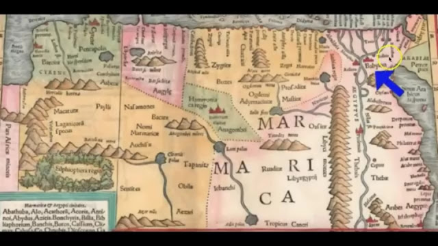
Babylon shown along the Nile


This original 1450 map was cartographed right-side-up, showing Egypt in the South and Babylon in the West side of the Nile (use Libya's position for clue)

A very important 1575 Map writes this;
"Cairus qvae olim Babylon; Aegypt maxima urbs"
It translates to: "Cairo which was once called Babylon; Egypt's largest city".

It is proof of Babylon spanning the entire region... But there's more.
Yashar/Jasher's account of the Tower of Babel
Yashar 9:28
"And behold these ascended and others descended the whole day; and if one brick should fall from their hands and get broken, they would all WEEP OVER IT, and if a Man Fell and Died, NONE of them would look at him."
Vs 37-39
"And they ceased building the city and the tower, therefore he called that place Babel, for there, YAHUAH confounded the language of the whole earth. Behold, it was at the EAST of SHINAR."
Barashyth/Genesis 11:2-3
"As people journeyed EASTWARD, they found a plain in the land of Shinar and settled there. And there they said one to another, "come let us make bricks and bake them thoroughly"
Map showing Babelmandel (East of Shinar/Sennar)

Abraham Ortelius 1592 - Babelmelech, Babelmandel, Medra (Media and Persia)


Babelmelech (bab el melech) means "kingdom of Babel"
Most likely, the royal palace was located in that region.
Babelmandel (bab al mandab) means; "gate of tears"
According to the book of Yashar/Jasher, The Most High YAHUAH destroyed the tower of Babel in three sections. The first was with the destruction of one-third of the tower in the above section, the second, the earth opened up it's mouth and swallowed another one-third of it while the remaining one-third of it, which was the middle section was left, but in ruins.
It's no surprise that in an Arab legend, there is a tale of a terrible earthquake that caused so many people to drown in that region and also brought about the separation of the horn of Africa from Arabia and Asia as a whole.
A sad lament went up there as a result of the great death toll the quake wroth and the almost complete separation of the horn of Africa (it was much later very well separated by humans and machinery for trade purposes through water during the infiltration and taking over of Africa by Europeans).
That place was called Bab el mendeb/ bab al mandab.
It is the exact location ancient maps points "babelmandel"... could this be a coincidence??!

To What Extent was Babylon Cursed?
YaramYAHU/ Jeremiah 51:29
"And the land shall tremble and sorrow: for every purpose of the ALUAH shall be performed AGAINST Babylon, to make the land of Babylon a DESOLATION WITHOUT An INHABITANT"
YaramYAHU/Jermiah 51:25
"Behold I am AGAINST thee, O destroying mountain, saith the ALUAH, which destroyest all the earth. And I will stretch out mine hands upon thee, and roll thee down from the rocks, and will make thee a BURNT MOUNTAIN"
Ever heard about the Taka Mountains?
These mountains are located in Kassala.
Kassala is the Capital of the State of Kassala in Eastern SUDAN, the region of Ancient Babylon.
You can look up the information about this region and the Taka Mountains and see for yourself. The mountains look as burnt as you'd ever see a BURNT mountain. There's no written history as to how a whole mountain with a large circumference could've been remotely burnt from the base to the tips. It could ONLY be as a result of the one who created it. The Most High!
Shouldn't this be a sight for wonder?
Oh, but NO! it had to stay hidden or people are going to begin to ask questions.
Pictures of Taka Mountains


Mosque built beside the Taka mountain

In The History Of Kassala And The Province of Taka, here is how D. C. Cummings described it in his Journal Article, Sudan Notes and Records Vol. 20, No. 1, (1937) Pages 1-45 published by University of Khartoum.
In page 1 of Chapter 1, he said; "The hills of the desert are usually bare and rocky, rising blatantly from the plain: Jebel Kassala carries this blatancy to a grotesque completeness. Although the sheer mounds of granite of which it is made of rise in splendid confusion to a height of 2,000 feet, there is no tapering peak to lighten it's mass, no green vegetation to relieve it's colour and seldom a cloud in the sky to cool it's sides. At sunset Jebel Kassala may claim some admiration, by moonlight it has an archaic dignity, but at noon, when the outline of the rock is diffuse in the heat, it is little more than a repulsive geological phenomenon."
Cumming made note that the Taka escaped the French invasion to Egypt in 1820 as led by Napoleon Bonaparte... as he and his troops focussed solely in the Sennar province and in Egypt. Also adding that much of the history of the Taka is unknown.
The people of old in the region of present-day Sudan and Egypt which we can see now was formally the Babylonian Empire, was a dwelling of people of colour, so called "Black" men. So much that, when Napoleon saw the Pyramids and statues in Egypt, he ordered his troops to shoot off the nose and lips of all of them... so many!
Question:What was it about the Nose and Lips of the statues that was repulsive to Napoleon?
Answer: The lips and nose of those statues told of the stories of those that had built it and was a reflection of those who were living there at that time. He couldn't bear to see that "blacks" owned and controlled an empire of magnificent structures that ruled the entire world.
Do you doubt it? The respected Dominique Vivante Baron Denon, who was a diplomat and artist from France accompanied and saw the statues before Napoleon and his troops shot off their noses and lips... He said this about the statues; that they were "typically Negro in all it's features" and he drew his rendition of the Sphinx of Giza just the way he had seen it before it was defaced.


Although, his work has been shrouded as a myth by the elites and even, fabrications of other reasons as to why the Sphinx has no nose has been in circulation, he (Denon) still held firm to all he saw and the books he wrote while he was on his deathbed and his witness, Herodotus attested to his claims... yes! He had a witness too.
It is easy to disprove his (Denon's) claims of Napoleon shooting away the Sphinx's nose, but what about the many other statues of Egypt whose noses and lips were destroyed, did they just fall off?


If you were a white "supremacist elite" trying so hard to refute the great civilizations of blacks (just like Napoleon was horrified by the sight of the behemoth structures and wanted to destroy what he saw), how far would you go to cover up the truth?
White supremacists' response would be something like; 'kill the original owners of the land, subjugate the ones left, assume leadership and authority over it and whiten out it's population (through the process of blanqueamiento) to support our narrative that the ancestors of Egypt were of European descent.'
I digressed...
YashaYahu/ Isaiah 13:22 describes Babylon as an Island, which means it was surrounded by water.
The ancient city of Meroë which was the Southern Administrative centre for Kush/Cush, became the capital after Napata- ancient Nubia (it's former capital) was sacked by Pharoah Psamtik II in about 590 BC according to Britannica.
Meroë is located between the White and the Blue Nile and the waters which flowed around it improved it's fertility and productivity, making it widely prosperous.
Now, Meroë is a ruined, dry, deserted and abandoned city, forgotten by time and all her esteem vanquished as prophesied.
Askumite invasion, "climate change" hoax, over-use of soil or deforestation could be widely blamed for the desertification of Meroë by nay-sayers but is it a coincidence that Egypt which is almost as old as Kush/Cush is still surviving today despite all it's encounters throughout history, and her brother and neighbour, the delight of the nations is in ruins? It's no coincidence.
Just as was prophesied, it came to pass... the Kingdom of Kush has fallen!
For Clarity: Noah had three sons; Sham/Shem, Ham and Yapatha/Japheth. Ham had four sons; Kush, Matsarym(Egypt), Phut and Kanaan (Canaan). The target was Babylon, the location Nimrod ruled when the tower of Babel was built... Geographically, the location of the Kingdom of Nimrod, son of Kush, grand-son of Ham... present-day Sudan.
Barashyth/Genesis 10:8 "And Kush begat Nimrod..."
Moving forward...
Ever heard that there are other Pyramids in Africa besides the great Pyramids of Giza in Egypt?
In ancient Meroë, the Capital of Sudan and in Sudan generally, there are over 200 pyramids. Although, not as large as the Pyramids of Giza, but 200 pyramids is and should be note worthy especially when it comes to identifying the true location of ancient Babylon.
Knowing that Babylon was (and the Spiritual one is) a whoring nation, sacrificing their babies to idols and deities by burning them up in the fire, worshipping idols made of stone and wood, etc. Therefore, a region that's situated with an enormous amount of idolatory CANNOT and SHOULD NOT be ignored or overlooked.
It's rather funny that these regions have been hidden for so long and only a few know about it.
Why is the government hiding such a site that is highly sought after and "celebrated" in a world like our's today?
Or are they deliberately turning our focus away from these regions (Africa)?


s
According to the main stream media, Pyramids were solely for the purpose of burying ancient rulers like Pharaohs' but some theories have shown better because, why would anyone put in much effort to build a pyramid structure, so magnificent and to so precisely fit other major functions like illumination (even having batteries and electrical generating properties that can feed a city or more) just to bury the dead?
And yet, they keep unearthing mummies of importance...even Pharoah's from isolated tombs (not in the Pyramids).
Still, if it's just for dead Pharoahs' and old tales of curses, why are the elites so interested in the Pyramids of Giza and these region even at the risk of being cursed or "hexed"?
I believe it is because of the secret it holds about the ancient preserved things and the Anunakis- the occult thrives in secrecy... if there is no secret, they would have no business with it.
Because this post is about ancient Babylon, I'll skip this.
To know more TRUTH about what Pyramids were originally built for, I implore you to do some research.
Going forward...
Jenni Marsh of CNN published an article called INSIDE AFRICA. EXPLORING SUDAN'S FORGOTTEN PYRAMIDS.
Here's what the Article says in it's description of the Area.
Remember, it's important for the Scriptural Babylon to be located by the Nile.

●[I won't be inserting all the pics for copyright reasons, I'll comment under "point to note." But using descernment, please pay attention to every detail and insinuations to the description of what we now know is ancient Babylon]●
Pic one.
"In Sudan's NILE Valley, there's a SERIES of ANCIENT TOMBS and PYRAMIDS that are RARELY VISITED by tourists.
Point to note:
There's the Nile Valley and there are series of ancient tombs as well as pyramids. These are distinguished.
Also, there's little or no visitors to the region.
Pic two.
These kingdoms date back to the kingdom of Kush, a MAJOR POWER between the 8th Century B.C and 4th Century A.D

Point to note:
Kingdom of Kush dates back to the times after the flood.
Noah had three sons; Shem, Ham and Japheth.
Ham is the father of Kush and Kush is Nimrod's father. Nimrod was King over Babylon.
Though they wouldn't want to use the term, "Babylon", looking at the dates from the time of creation, you can't miss it.
Pic three.
Tourists wishing to see the Pyramids MUST TRAVEL IN A JEEP and then, by CAMEL or FOOT to ACCESS the REMOTE SITES.
Points to note:
Just like scriptures foretold, Babylon will be desolate with no one inhabiting the area. If it's expedient that they travel in a jeep, then camel, and even on foot, it is because there are no roads. We know roads are one of the very basic amenities for a community (if one exists) to transport people, goods and services. Basically to trade so they can develop and sustain themselves.
Pic four.
According to UNESCO, the WIDE RANGE of ARCHITECTURAL forms found at the Meroë --- A SEMI-DESERT landscape between the NILE and Attbara rivers is proof of contact between sub-saharan Africa and the Mediterranean Middle Eastern worlds in this period.
Points to note:
Meröe, Sudan is actually historically an island just as scriptures describe Babylon. It was foretold that it's rivers will dry up.
Here, Meröe is described as a semi-desert because it wasn't originally a desert and thus cannot make it to the list of natural deserts just like the Kalahari desert that houses ancient Yarushalam/Jerusalem (please read the part 6 of the series for clarity)
Contact between the middle eastern region happened as most inhabitants fled Sudan through Egypt to the Middle East during a hot pursuit from ancient Assyrian armies (please read part 7 for the true location of Ashshur [Assyria] for more details)
Pic five.
Meroë is an ANCIENT CITY that was the Capital of the Kingdom of Kush for SEVERAL CENTURIES. The pyramids here housed the REMAINS of the DECEASED KUSHITE RULERS.
Points to note:
Yes, Meröe is an ancient city...
We see how this is very reminiscent of the Kingdom of Egypt?
Napata which was the first capital, houses the Nubian cult centre of Amun/Amen...ancient Egypt in sudan.
So, it's really from Babylon to Egypt.
Pic six.
More than 200 pyramids are believed to be located In Sudan. About 117 are located in the Island of Meroë, while the other 74 are in the Nuri region.
Points to note:
These shows some of the influence when it comes to how this Kingdom was spread.
Pic seven.
The Sudan pyramids are smaller than those in Egypt. They are also LESS BUSY, typically receiving about 10 visitors per day.
Points to note:
I couldn't help but exclaim 10?!
Like only 10?!
There are places in the world with little or no historical value with hundreds of thousands of visitors and here is only 10 a day? Not to mention, but it's neighbour pyramid is close by with an all time high number of 14.3 million visitors in 2010. For perspective, in that same year, France was at 8.2 million vistors. This is according to Forbes.
The scriptures never lie! It was foretold of and we see it happening.
Pic eight.
Visitors are able to CAMP at the FOOTSTEPS of the Pyramids overnight. And sometimes, they have to. THERE ARE NO HOTELS OR RESTAURANTS NEARBY.
Points to note:
Wow!
Provision for camping at the foot of a "mummy" house is available to pass the night because there are no establishments there. Anyone who comes, does so for a purpose and leaves. No people, no culture to wait behind and see.
Pic nine.
Stone shrines line the entrance to the Amun Temple in Naga.
Point to note:
Amun or Amen is the hidden Theban god of the wind and fertility and seen as the most important god of all the many gods in Egypt. Also known as Amen ra or Amun ra. Ra meaning Lord, just like baal.
When we pray as believers and end with "Amen", we are unknowingly giving honour to an Egyptian deity. We need only to pray in the Name above every name , which is YAHUSHA (This means YAHUAH is Salvation)... we don't need an "end word"
Just to be clear, the word in Yahudyth (Hebrew) which means "truly" or "so be it" is "Amanu" and you see it in Strong's Concordance (H539, H540, H543)
It's better to say "so be it" in an agreement prayer than to conjure up a demon.
But the Catholic church and her sister religions "coincidentally" agree on this "one" word (amen). Is it really a surprise or a coincidence?
Pic ten.
Some of the wall carvings on the Sudanese Temples are reminiscent of ANCIENT EGYPTIAN ART.

Points to note:
Yes indeed.
That is because, Egyptian civilization is stemmed from ancient Babylon.
Pic eleven.
Rulers of the Kushite kingdom were known as the Black Pharaohs. They were a MAJOR POLITICAL POWER until the 4th Century, according to UNESCO.
Points to note:
Which other civilization is said to have major political power if not from a Babylonian system?
They were not just known as the black Pharaohs, the 'Pharaohs' in ancient Egypt were literally black (dark/brown skined).
Egypt is a historically black populated land.
These goes further to show that from creation, the world was dominated with the black race... Adam, eve, cain, Abel, Enoch, Noah and sons, Kush and Nimrod, etc. were all dark skinned people.
This is just the truth.
Pic twelve
The landscape leading up to the UNESCO WORLD HERITAGE SITE is dramatic, with sweeping sand dunes and clear skies.
Points to note:
What is UNESCO really doing in a place without inhabitants?
What do they know about these lands?
Why do they have an office stationed there?
Pic thirteen.
Local tour guides are available to take visitors to the sites but due to lack of a tourism industry in Sudan, they often Do Not Know Much of the Local History.
Points to note:
These narrative to a sleeping public is just the same as saying; 'don't expect answers to your questions...' in order words; we have people to take you around, but they're gonna be playing dumb.
Or could it be really, they don't know because no one has been inhabiting these lands for so long now that they are being forgotten like it was foretold of them?
This CNN's post is really revealing!
Ok! Moving forward...
We know Rome has encountered this region in time past. Is there proof of Rome in this region besides the ones in The Nile Delta / Babylonian Fortress?
The answer is YES!
Naqa or Naga'a is a RUINED CITY of the Kushitic Kingdom of Meroë in Modern-day Sudan BY THE NILE.
Being one of the important centres and largest ruined sites, it has two notable temples. One devoted to Amun/Amen and the other, to Apedemak.
In Apedemak, there is a Roman Kiosk ruin-remains built in their typical structures like EDOM (see part 3 of the series).

The Kingdom of Kush was an ancient kingdom in Nubia, located at the Sudanese and Southern Egyptian NILE Valley. With it's imperial Capital at Meroë during the Classical Antiquity.
After the fall of Neo-Babylonian Empire, the city came under the rule of some Empires which includes the Roman Empire. Hence, some Roman Structures in ancient Babylon (Sudan).
Now...
The question of the actual remains of the ruins of the tower of Babel still remains.
Seeing that it was recorded in the book of Yashar/ Jasher that it was one-third of the tower that survived in ruins (the middle section of the structure), we could only expect to see just so so... given the thousands of years that have passed.
Let's take it gently.
Moving Forward...
Is there a proof of Askumite presence in this region?
A little background history shows us that there was a time the Kingdom of Askum was established in Babylon... some archaeologists blame the Askumite invasion for the destruction and desolation of the region.
What factors led to the rise of Aksum?
"When Askum conquered Kush, they gained more power. They also had access to trade to the Red Sea, Mediterranean Sea, Indian Ocean, and the Nile Valley. Aksum then became a trading center like Kush had been, which led to the rise of Askum." By Wikipedia.
We know the identity of Kush, son of Ham, grandson of Noah... the progenitor of the Kingdom of Babylon... whose brothers' descendants; Matsarym (Egypt) and Phut still live in that region to this day... besides Kanaan (Canaan) who after the destruction of Babylon, coverted and moved to a land that wasn't originally his, incurring another curse.
Yubalym/ Jubilees 10:28-34
"And Ham and his sons went into the land which he was to occupy, which he acquired as his portion in the land of the south. And Canaan saw the land of Lebanon to the river of Egypt, that it was very good, and he went not into the land of his inheritance to the west (that is to) the sea, and he dwelt in the land of Lebanon, eastward and westward from the border of Jordan and from the border of the sea. And Ham, his father, and Cush and Mizraim his brothers said unto him: 'Thou hast settled in a land which is not thine, and which did not fall to us by lot: do not do so; for if thou dost do so, thou and thy sons will fall in the land and (be) accursed through sedition; for by sedition ye have settled, and by sedition will thy children fall, and thou shalt be rooted out for ever. Dwell not in the dwelling of Shem; for to Shem and to his sons did it come by their lot. Cursed art thou, and cursed shalt thou be beyond all the sons of Noah, by the curse by which we bound ourselves by an oath in the presence of the holy judge, and in the presence of Noah our father.' But he did not harken unto them, and dwelt in the land of Lebanon from Hamath to the entering of Egypt, he and his sons until this day. And for this reason that land is named Canaan.
Yahusha/Joshua 9:23
Now therefore ye are cursed, and there shall none of you be freed from being bondmen, and hewers of wood and drawers of water for the house of my ALAHYM/ELOHYM.
**do not confuse Jordan and some locations with the middle east... also, the rivers of Egypt flow from the southern Africa to the north, not the other way around. See part 6 of the series**
Continuing...
When Askum was excavated, ancient ruins and artifacts which pre-dates the Axumite Kingdom were uncovered... could you take a guess at whose ruins were exposed?


My theory is this; In addition to the facts, at the location that was named "gate of tears" (bab el mandeb strait) which is at the point where the horn of Africa is separated, there is an "Island" called Perim which to me is very suspicious seeing the way that it wasn't excavated. It has No Water, no vegetation, has no natural resources even though it's described as a "Volcanic Island" and, no one is able to live on it permanently because of the lack of all of these aforementioned. Also, the Island has gone through several military presence, conflicts and controversies from many nations till date... showing it's "importance" to history.
In the 8th Edition of "Red Sea and The Persian Gulf" publication of Sailing Directions (enroute), Pub. 172, Pg 69 Babel Mandeb 5.19 (12° 31'N, 43°'E) the "island" was described.
"The S entrance of the Red Sea is divided by Perim into two straits. Large strait lies between the African shore on the W and SW and Perim on the NE; small straits lies between the latter "Island" and the Arabian shore..."
figure7.83 says; "Perim (12°'40N, 43°25'E) lying on Babel el mandeb, is bare, rocky and rather flat in appearance; the surface is broken into a dense layer of boulders and stones, and covered in places with wind blown coral sand. It is devoid of vegetation and is grooved with watercourses. This Island is even and unbroken and should not be mistaken for the high and irregular land of ras Bab al mandab... Perim is contained within an area, best seen on chart, that is prohibited to navigation."

**Please turn device to the right to view map**
The Edinburgh Encyclopedia, Vol.3 says this about Babelmandeb "... The straits are divided by the "island" of Perim, which is perfectly flat, and about three miles from the Cape. East longitude of 43°33', North latitude 12°40'."
Sailors' have to navigate carefully past it as is it positioned almost central of bab el mandeb strait.
Yashar/Jasher 11:37-49
"And they ceased building the city and the tower; therefore he called that place Babal/Babel, for there YAHUAH confounded the language of the whole earth; behold it was at the EAST OF THE LAND OF SHINAR.
And as to the tower which the sons of men built, the earth opened it's mouth and swallowed up one third thereof, and a fire descended from heaven and burned another third, and the other third is left to this day, and it is of that part which was aloft, and it's circumference is three days walk.
And many of the sons of men died in that tower, a people without number."
I'm led to see reason that Perim could be part of the ruins as it is located at the region of the terrible earthquake that caused the horn of Africa to separate... the destruction of the tower of Babel was massive (especially at the topmost, and the base of the tower). The "Island" of Perim might be a part of the tower that fell in the river and survived so long it begun to mold to look like a perfectly bouldered island but, still lacking in natural resources of any kind as a proof that it developed through sedimentation or by any natural means... therefore, it may never have been originally and Island but a ruin of some sort.
It is not easy to absorb most of these... very true indeed. But, present day "Babylon" looks nothing like what was prophesied against the true Babylon of the scriptures; of desolation, with no inhabitants, forgotten, burnt mountains and Jackals inhabiting the land (look up maps showing Jackal distribution in true Babylon-Sudan and the Kalahari desert that houses the true Jerusalem location. See Part 6).
Geographically, it (present-day Babylon) doesn't fit in locations of historical events of that magnitude (Babylon), seeing and using Egypt as a historical land mark along with the cradle of civilization-Nile and the Nile Delta (Babylonain fortress for Rome).
Academically, information and truth is most often controlled and altered with main stream constantly re-directing the populace to what is "acceptable" but not true.
But we see ancient maps pointing to a not-so-popular one in Africa and we have neglected sources like Dr. Dierk Lange showing proof of Ancient Akkad, Assyria and Babylon spanning North-East to West Africa.
Also, we see Sennaar/Shinar, Medra (Media and Persia), Ammon, Agag, Tigris River, etc. in Africa.
Geologically, the natural resources of ancient Babylon was majorly the Nile river, the rainfall, fine stones, farming and metals. They depended on the fish from the rivers, they built with the stones, and with the metals, they made wheels, timber, clocks, etc... same culture the Egyptians had cause they were in the same Region and even took over in esteem when Babylon fell as Babylon was established before Egypt was.
The natural resources found in ancient Iraq conflicts with the information from ancient Mesopotamian region (which is Ancient Akkad-Assyria and Babylon) because it is two different/ parallel regions.
Crude oil was founded in Iraq nine years after the first World War. If you're in doubt, please look up the major owners and controllers of the oils in Iraq for many years and you'd be amazed.
Why all the lies and massive cover-ups?
It's a means to control the whole inhabitants of the earth through deception at the expense of our souls. Remember whom the father of lies is? Yes! Ha' Shatan/Satan.
Khazun/Revelations 12:9
And the great dragon was cast out — that serpent of old called the Devil and Satan, who deceiveth the whole world. He was cast out onto the earth, and his angels were cast out with him.
But...
Yahuknn/John 14:6
YAHUSHA is the Way, the Truth and The Life!
And He's the ONLY way to the Father.
In all things, seek YAHUAH the Father and YAHUSHA the Son to lead you into all Truth.
Stay Baruk!
Favour Abam
#favyabam
#truthtothenations
Credits:
●Truthunveiled777
●Dr. Derek Lange
●Wikipedia
●Encyclopedia Britannica
●Google Map
●D. C. Cummings
●Jenni Marsh of CNN
●Freeman Institute Black History Collection
●The Edinburgh Encyclopedia
●Sailing Directions
●Amy Maxmen of Nature Magazine
Disclaimer: I do not own copyright of any pictures or maps. They are being used strictly for educational purposes.
Comments
Post a Comment